

Mapping Hostil-ISM
Global Infrastructures of Displacement and Mobility
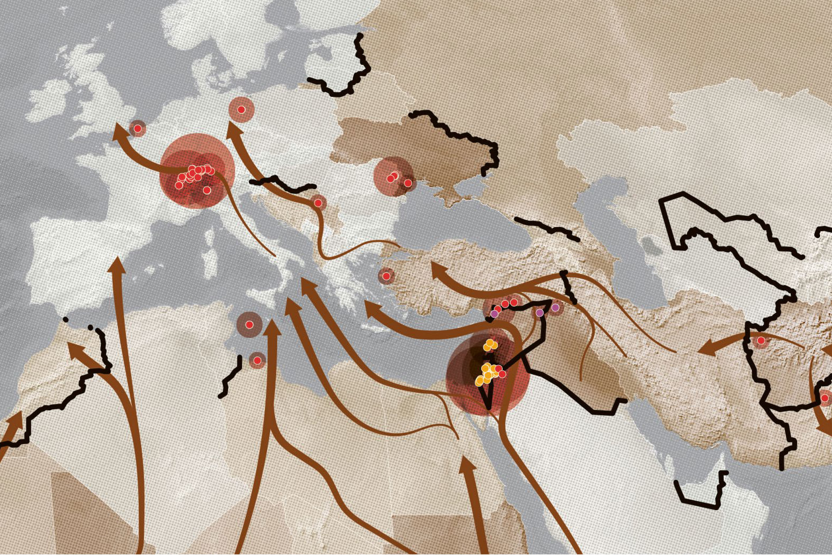
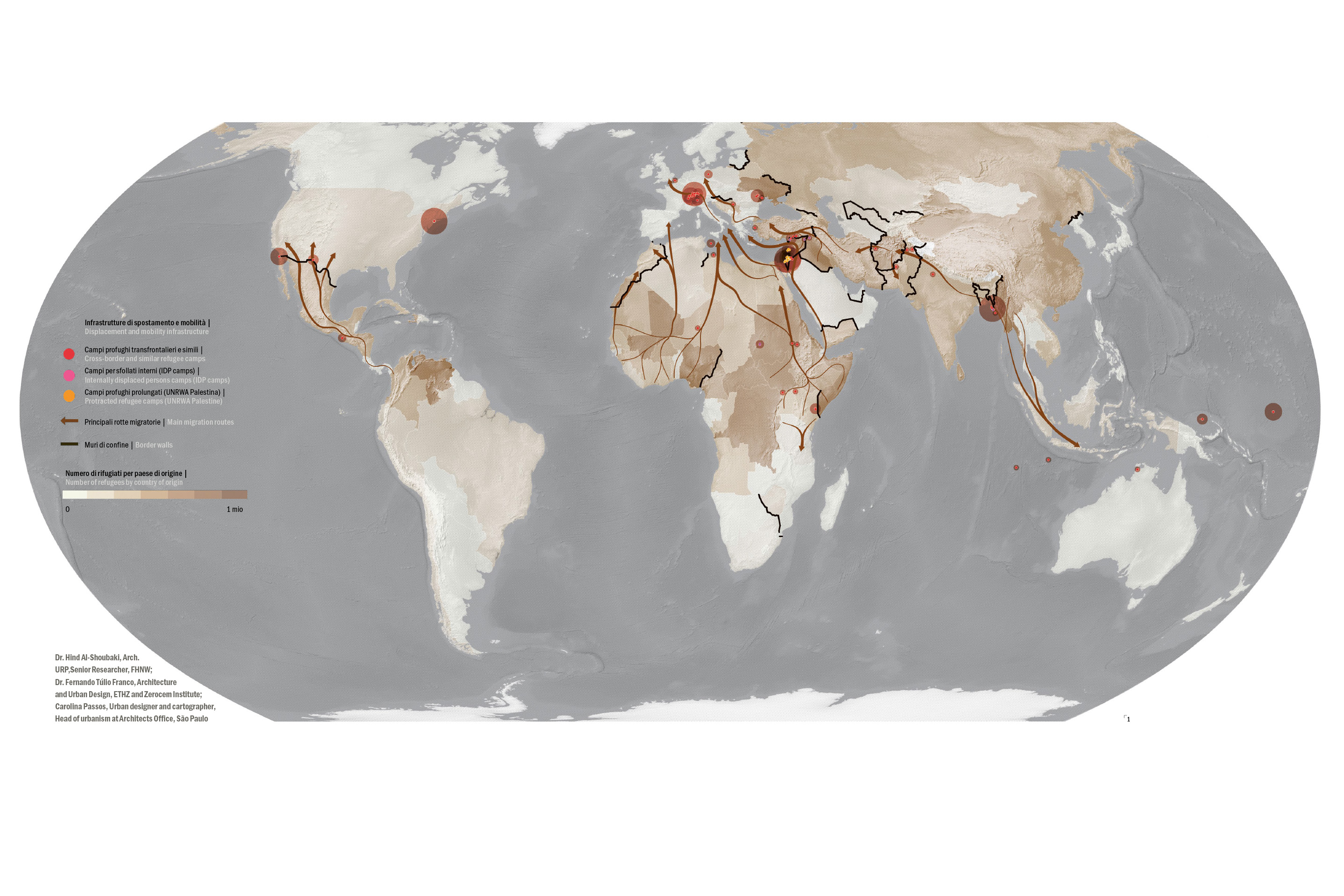
Camps, borders and reception centres are not exceptions, but rather elements of contemporary spatial infrastructure. Mapping Hostil-ISM charts the global geographies of displacement, examining the relationship between mobility, governance, urbanisation and the right to housing.
Testo in italiano al seguente link
«Mapping Hostil-ISM: Global Infrastructures of Displacement and Mobility» is a cartographic work situated at the intersection of critical urbanism, humanitarian studies, and spatial research. Presented at MuBE in São Paulo as part of The Third Margin of the City: Paulo Mendes da Rocha and the Challenges of Life on the Planet, the map emerges from the Swiss Network for International Studies (SNIS) research project, Camps and Camp-Like Settings in Urban Environments: Bridging Humanitarian and Development Activities. The project examines camps and camp-like settings across Switzerland, Jordan, and Moldova, using a comparative lens to understand how displacement is governed, spatialised, and embedded within urban and territorial systems.
The work proposes a planetary reading of forced displacement. Rather than representing camps, reception centers, transit facilities, or internally displaced persons’ sites as isolated humanitarian spaces, the map positions them as nodes within wider infrastructures of mobility, containment, governance, and unequal access. In this sense, the map resonates with Agier’s understanding of camps as spaces produced through humanitarian government, where protection and control are often intertwined.1 It also engages with Ramadan’s argument that refugee camps must be analysed not only as bounded territories, but as spatial formations shaped by law, politics, memory, and everyday urban practices.2
The title Hostil-ISM plays on the ambiguity between hospitality and hostility. It suggests that contemporary systems of reception often operate through a paradox: they offer shelter, protection, and administrative recognition, while simultaneously producing conditions of waiting, surveillance, dependency, exclusion, and restricted mobility. Camps and camp-like settings, therefore, cannot be understood only as emergency responses. They are also spatial technologies through which states, humanitarian actors, and international organizations manage displaced populations and regulate their relation to territory, rights, and the city.
The central question of the map is: how is emergency spatially organised? The work challenges the idea of emergency as a short-term or exceptional condition. Instead, it shows how emergency often becomes durable, material, and infrastructural. Temporary shelters become neighborhoods; reception facilities become long-term administrative landscapes; refugee camps become urbanized districts; transit spaces become spaces of prolonged suspension. This transformation echoes Sanyal’s work on «urbanizing refuge,» which demonstrates how spaces of displacement are continuously reshaped through informal practices, humanitarian interventions, political constraints, and everyday forms of adaptation.3
The map distinguishes three main typologies. The first includes cross-border refugee camps and camp-like settings, such as UNHCR camps, national reception centres, offshore processing spaces, and transit islands. These are formal or semi-formal infrastructures created to host people displaced across international borders. The second typology concerns protracted Palestinian refugee camps administered by UNRWA. These camps occupy a unique position in the global history of displacement: they emerged from the Nakba of 1948, extend across several host contexts, and have become urbanized, generational spaces governed through a distinct international mandate. Here, the map draws conceptually on scholarship on Palestinian camp urbanism and the long-term spatial politics of exile.4 The third typology includes internal displacement nodes: sites hosting people displaced within their own national borders. These spaces differ legally and politically from refugee camps, yet they often share similar spatial conditions of precarity, provisionality, and limited access to rights.
The use of the Equal Earth projection is not only a technical decision but also a critical one. By using an equal-area projection, the map avoids some of the distortions historically associated with conventional world maps and allows continents and regions to be read in more proportionate relation to one another.5 This choice reinforces the map’s broader argument: displacement is not a marginal or exceptional phenomenon, but a planetary condition structured by war, colonial legacies, border regimes, economic inequality, environmental crisis, and uneven forms of mobility.
As Harley argued, maps are never neutral mirrors of the world; they are cultural and political texts that produce particular ways of seeing.6 Mapping Hostil-ISM, therefore, does not claim to offer a complete representation of displacement. Rather, it makes visible a set of spatial relations that are often fragmented across humanitarian databases, policy categories, legal definitions, and national systems. The map brings together points, lines, corridors, and territorial intensities in order to show how displacement is organized through infrastructures: camps, reception centres, humanitarian corridors, border zones, urban peripheries, and sites of containment.
Methodologically, the work combines international humanitarian datasets with research-based spatial knowledge. The map draws on sources such as the UNHCR Operational Data Portal, IOM’s Displacement Tracking Matrix, UNRWA camp profiles, and the Humanitarian Data Exchange, as well as case-specific information collected through the SNIS project for Switzerland, Moldova and Jordan. These sources are not treated as purely objective repositories of facts, but as part of the infrastructure through which displacement becomes knowable, governable, and administratively visible. In this sense, the map also raises questions about data politics: who is counted, where, by whom, and for what purpose?
Ultimately, Mapping Hostil-ISM invites architects, urbanists, researchers, and institutions to reconsider the role of space in forced displacement. Camps and camp-like settings are not outside the city; they are part of the contemporary urban and territorial condition. They reveal how mobility is distributed unequally, how emergencies become normalised, and how humanitarian infrastructures can both protect and immobilize. By mapping these global infrastructures, the work asks whether it is possible to move from a geography of conditional and often hostile reception toward a spatial politics grounded in dignity, justice, and the right to inhabit.
Notes
1 Agier, Managing the Undesirables.
2 Ramadan, «Spatializing the Refugee Camp».
3 Sanyal, «Urbanizing Refuge».
4 Allan, Refugees of the Revolution; Peteet, Landscape of Hope; Ramadan, «Spatializing the Refugee Camp».
5 Šavrič, Patterson, & Jenny, «Equal Earth Map Projection».
6 Harley, «Deconstructing the Map».