

From Shelter to Sūq
The Spatial Transformation of Al Wehdat Camp in Amman, Jordan and its Production as a Transient Territory.
When does a refugee camp cease to be a camp? Using the case of Al Wehdat, this essay explores how the market, infrastructure and daily life transform the space of displacement into an urban territory, where physical presence and the right of return remain in tension.
Testo in italiano al seguente link
The Spatiality of Protracted Displacement
The foundational question guiding the investigation into Al Wehdat Camp is one of spatial and political identity: Is Al Wehdat still a camp, or has it now become part of the city? To address this, I analysed the camp’s spatial transformation since its 1955 establishment by the Jordanian State and the United Nations Relief and Works Agency for Palestine Refugees in the Near East (UNRWA). I conducted extensive field research between 2019 and 2022 for my doctoral dissertation, utilizing qualitative tools including interviews, focus groups, and participant observation with inhabitants, shop owners, merchants, and state officials.
Through this inquiry, I conceptualize Al Wehdat as a dynamic territory shaped by flows of displacement, movement, and activity. These forces reproduce the camp as a transient territory experiencing a «doubling of space,» existing simultaneously in the past and present, at home and in exile. This spatial duality marks the intersection of displacement paths travelled by Palestinian refugees since the 1948 uprooting.1 This framing aligns with Abourahmeh,2 who argues that camps transform within the «spillovers» between material reality and governing legal frameworks, producing a condition of «permanent temporariness».3 Moving away from a static territorial view, this study deconstructs Al Wehdat as a complex urban morphology where sovereignty, markets, and everyday life intersect,4 rather than a homogeneous «non-place».5
Crucial to this inquiry is the tension between the camp’s political transience and its material permanence. While remaining a custodian of the internationally recognized right of return, its morphological evolution reveals deep urban integration. The original single-story shelters (wehdat) have transformed into four-story buildings indistinguishable in typology and regulation from surrounding Amman neighbourhoods. This physical reality is defined by extreme density; built for 5 000 people, the camp now accommodates an estimated 60 000 residents within a mere 0.48 km².6
Once isolated, Al Wehdat is now entirely embedded within Amman’s south-eastern urban sprawl, stretching continuously toward Jabal Ashrafiyya.7 This «temporary solution,» sustained for nearly eight decades, has generated an incremental architecture of informal expansions that drastically reduces green space and compounds environmental and social challenges.8 This transformation is managed through a model of «hybrid control» between the Jordanian State, through the Department of Palestinian Affairs (DPA) as the supreme infrastructure authority – and UNRWA, whose role has shifted from direct relief toward social services.9 This interplay produces a «zone of indistinction» that ambiguously includes the camp within national territory while enforcing its exclusion as a humanitarian space.10 Within this boundary, Sūq Al Wehdat (the market) serves as a primary site of everyday resistance,11 where economic vibrancy and gendered agency reframe refugee life as a condition of steadfastness (sumud) within a city-embedded archive.12
To analyze this double spatiality, I focus specifically on the emergence and spread of Sūq Al Wehdat. I argue that the market is the primary driver of the camp’s material and social integration into the city, facilitated through constant trade. Investigating the market as a spatial shaping force allows me to examine how its expansion shifted the camp’s identity from a secluded space of refuge to a local economic hub, blurring official boundaries through corridors of daily interaction. I trace how this commercial expansion systematically converted refugee shelters into shops, marking a fundamental shift from a residential site of refuge to a high-intensity space of commerce. By analysing the power relations shaping Sūq Al Wehdat, I investigate how these dynamics physically and socially reconfigure the camp. My analysis concludes with Sūq Al Nafoura (the Fountain Market), through which I read the camp as an urban palimpsest.13 Connecting Al Wehdat’s foundational period to the lost geography of Palestine, this site uncovers a hidden infrastructural history: the evolution of its hydraulic nodes. Tracing the transformation of these water distribution points from public utilities into commercial foundations reveals a subterranean dimension of integration into Amman. As a «space of memory»,14 the site projects the camp into the ancestral homeland, materializing this connection through market elements and spatial practices that re-inscribe remnants of pre-Nakba Palestinian life into the contemporary urban fabric. Synthesizing architectural collage with Ibrahim Nasrallah’s Birds of Caution,15 this research examines the visceral, gendered history of fetching water. This interdisciplinary approach peels back the physical and intangible strata of the settlement to expose evolving power dynamics, changing materiality, and shifting spatial practices. Ultimately, this methodology reframes the camp not as a static site of refuge, but as a living record of transformation and settlement.
Sūq Al Wehdat: The Market That Moves with the Movement of People
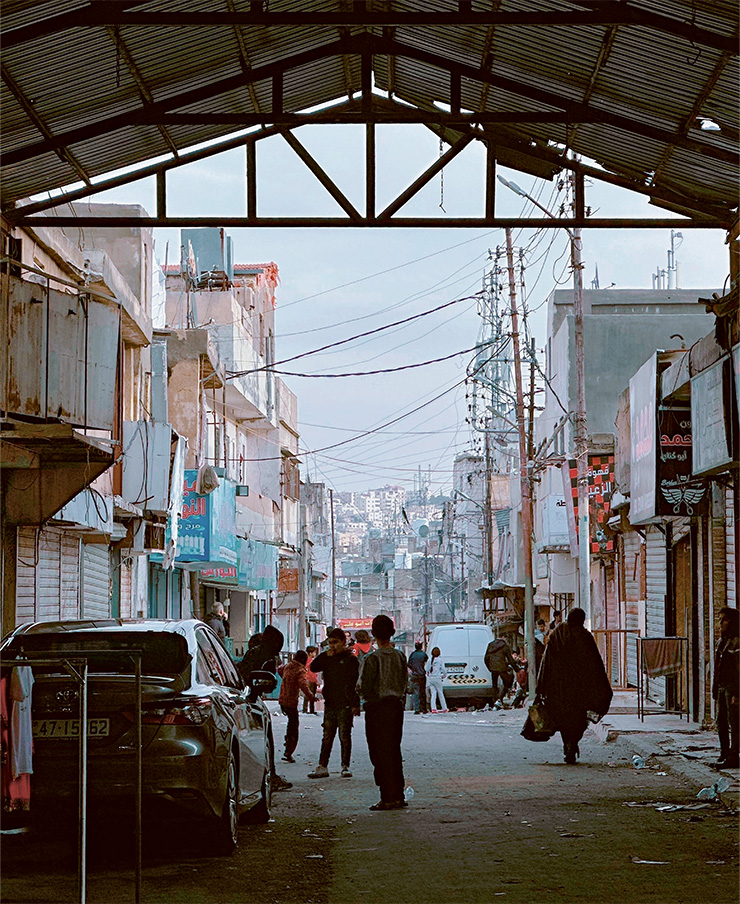
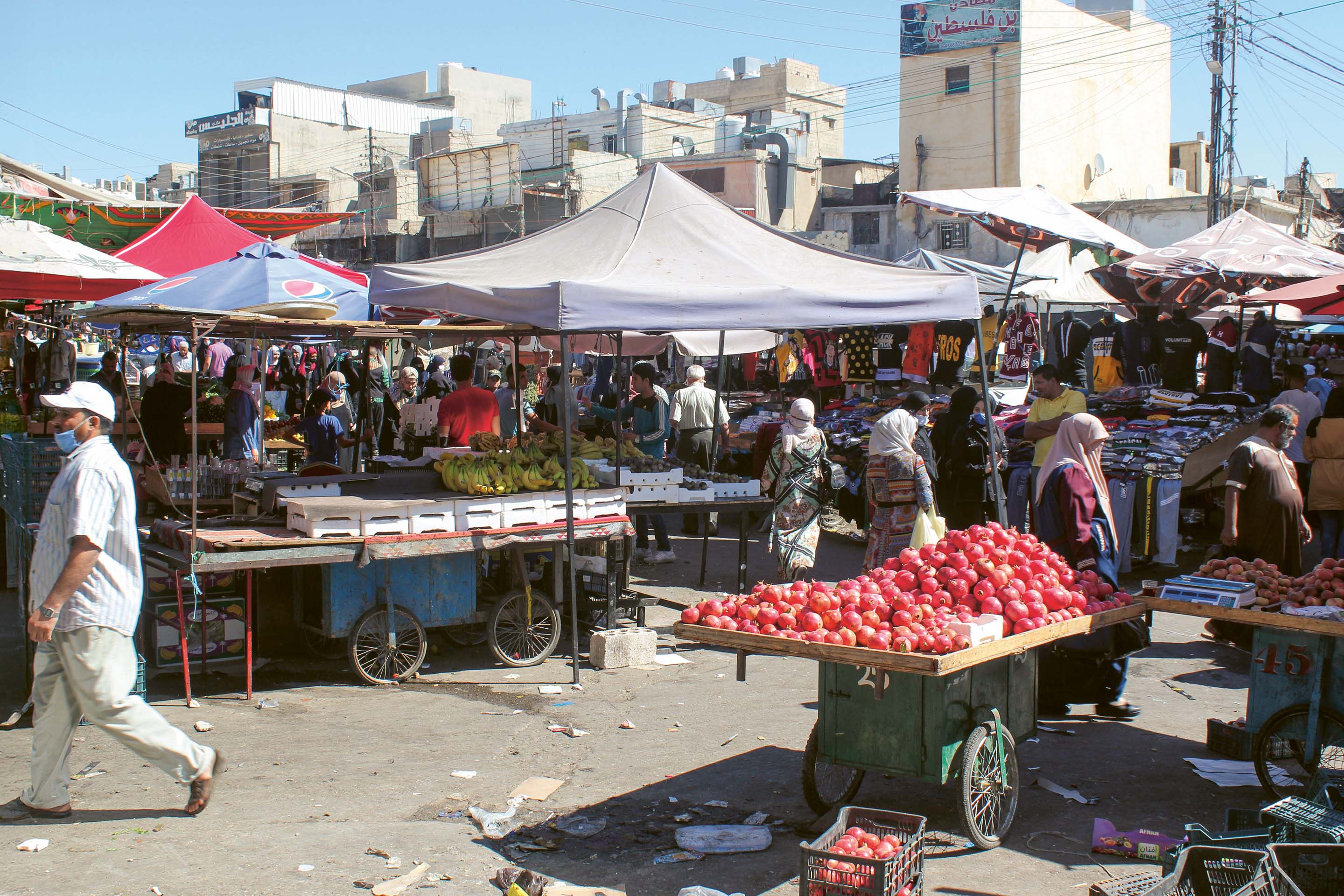
On the ground, a first-time visitor encounters a space that visually and functionally presents itself as an intense market rather than a refugee camp, raising critical questions about how commercial saturation can obscure a site’s underlying geopolitical reality. This overcrowding of commercial, human, and activity effectively swallows the residential infrastructure, making it difficult to trace the structural features of the built environment or read the camp’s history through its architecture. Furthermore, this intense commercialization creates a form of spatial insulation; because the commercial corridors pour directly into the main streets running along the camp’s edges, shoppers can engage in seamless pedestrian movement from outside the camp, through it, and out again. This layout means that consumers never need to venture beyond the market into the deeper residential neighbourhoods, effectively reducing a complex space of displacement into a transient, highly accessible shopping destination and sanitizing the visitor’s encounter with the camp’s interior reality.
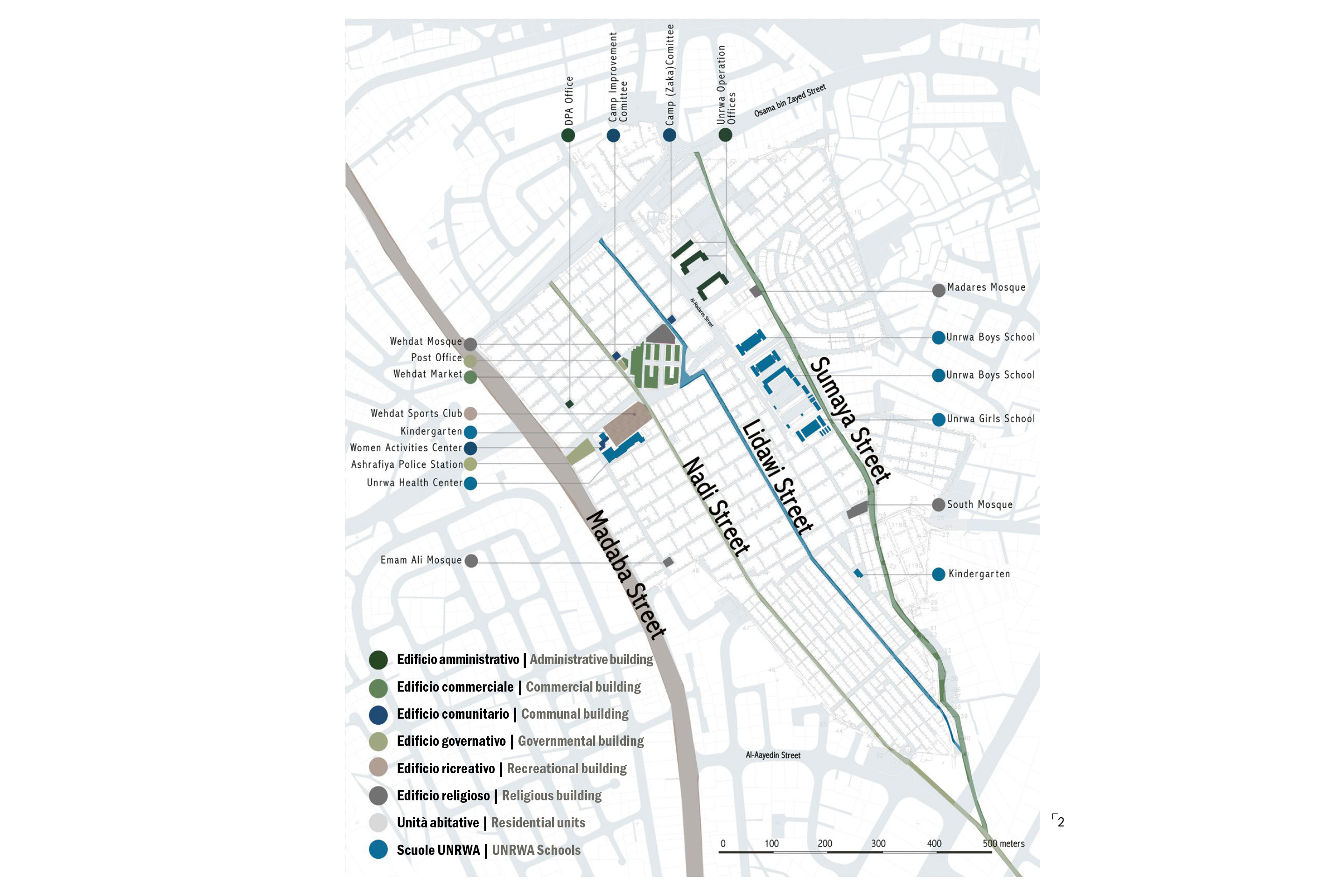
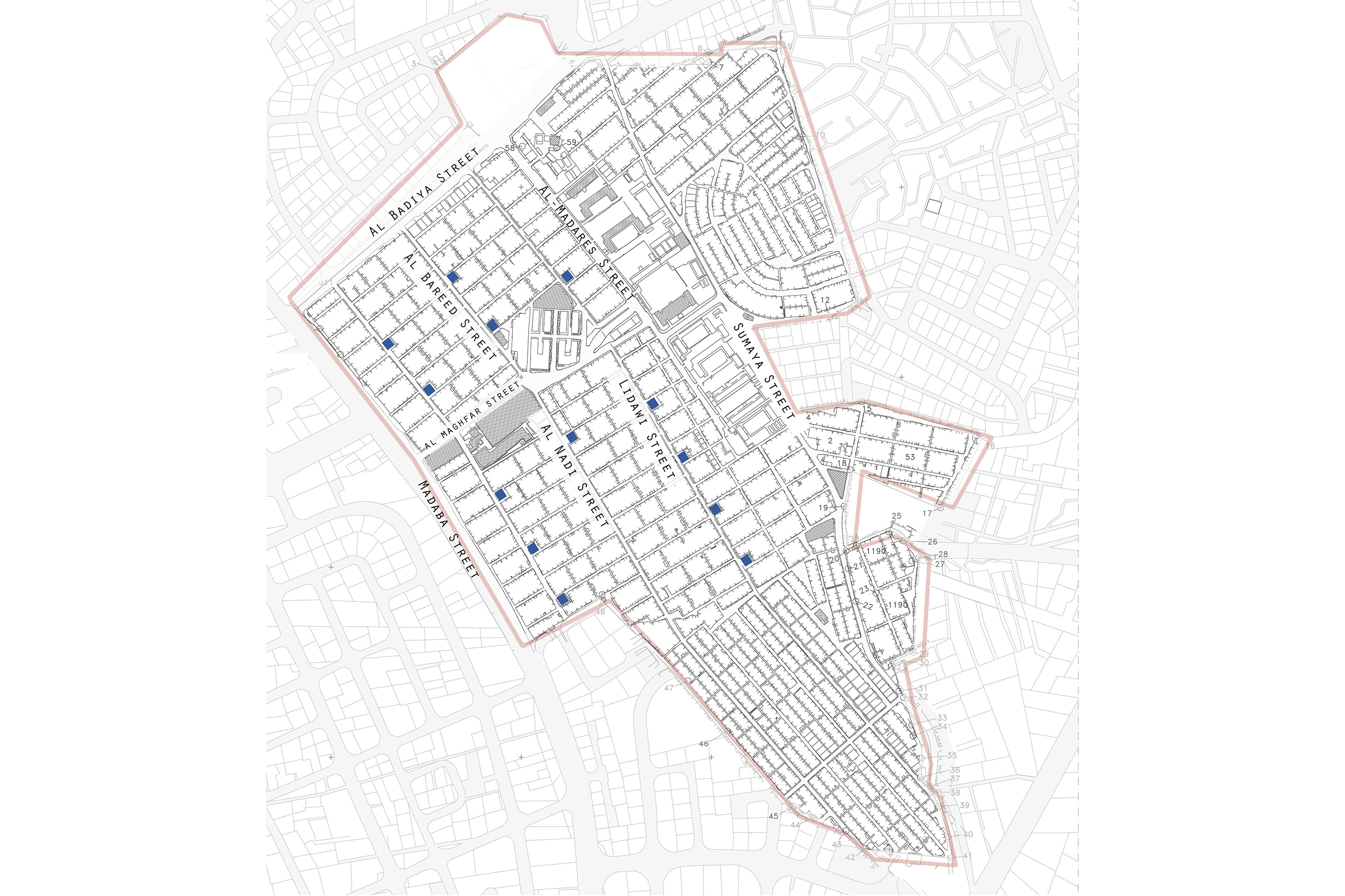
Al Wehdat Market is a fluid space where moving kiosks, vendors, and carts drive continuous expansion and the systematic occupation of the camp territory. As commercial demand grew, outside merchants offered attractive compensation to refugees to lease or buy their shelters, accelerating the conversion of residential units into storefronts. Historically, this intense commercialization is a recent phenomenon. Prior to the early 1980s, the camp was predominantly residential, containing only a small vegetable market and a limited number of shops for basic needs. According to the Director of the Al Wehdat Camp Services Committee (DPA), permitting wide-scale commerce in the early 1980s was an intentional state intervention designed to alleviate rising poverty. Regulations were altered to allow residents to convert 50% of their residential unit’s area for commercial use, sparking rapid development along main arteries like Al Nadi and Liddawi Streets. Subsequent decrees in 1997 and 2012 permitted vertical expansions up to four stories, explicitly allowing the first two floors to be dedicated entirely to commercial ventures while residents occupied the upper two. This legislative evolution mirrors the broader architectural and legal tension at the heart of this research: the transformation of the refugee shelter from a modular, temporary unit into a vertically expanding, commercially active structure – a built form embodying the contradiction between the politics of refugeehood and the materiality of permanence. To map the camp’s main landmarks and streets, figure 2 was produced.
The street hierarchy and commercial distribution were determined by three interdependent factors: public amenity distribution, physical street width, and proximity to surrounding main roads. Notably, the presence of amenities along a route was frequently dictated by its width and status within the camp, with more shops opening near streets offering more landmarks, width, and pedestrian flows. Importantly, none of the internal streets were given official names, but instead gained unofficial titles from the buildings and amenities along their length. Al Nadi Street, now the camp’s most vital commercial corridor, was named after Nadi Al Wehdat (the Al Wehdat Sports Club), the camp’s most famous building due to its local, national, and international prominence. Al Madares Street gained its name from the UNRWA schools complex consisting of twelve buildings, and Al Maghfar Street from the police station located at its entrance.
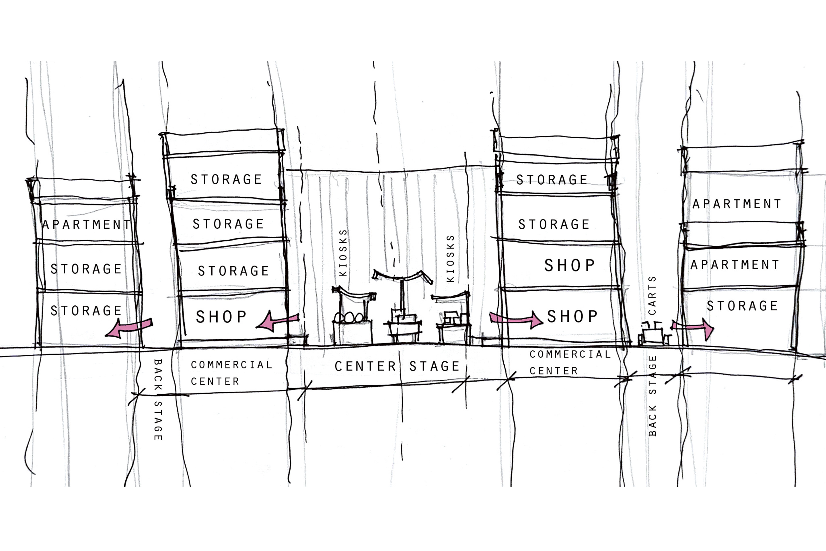
Liddawi Street was different, gaining its name from a distant landmark – the city of Al Lidd in Palestine, from which the majority of its inhabitants were displaced after the Nakba of 1948. This last naming is particularly revealing: it illustrates how commercial space in Al Wehdat is simultaneously a space of memory, where the geography of loss is quietly inscribed into the everyday of trade. To understand this spatial distribution more deeply, I drew a cross section along Al Maghfar Street to capture the relationship between the moving and the fixed layers that vertically overlap (fig. 3).
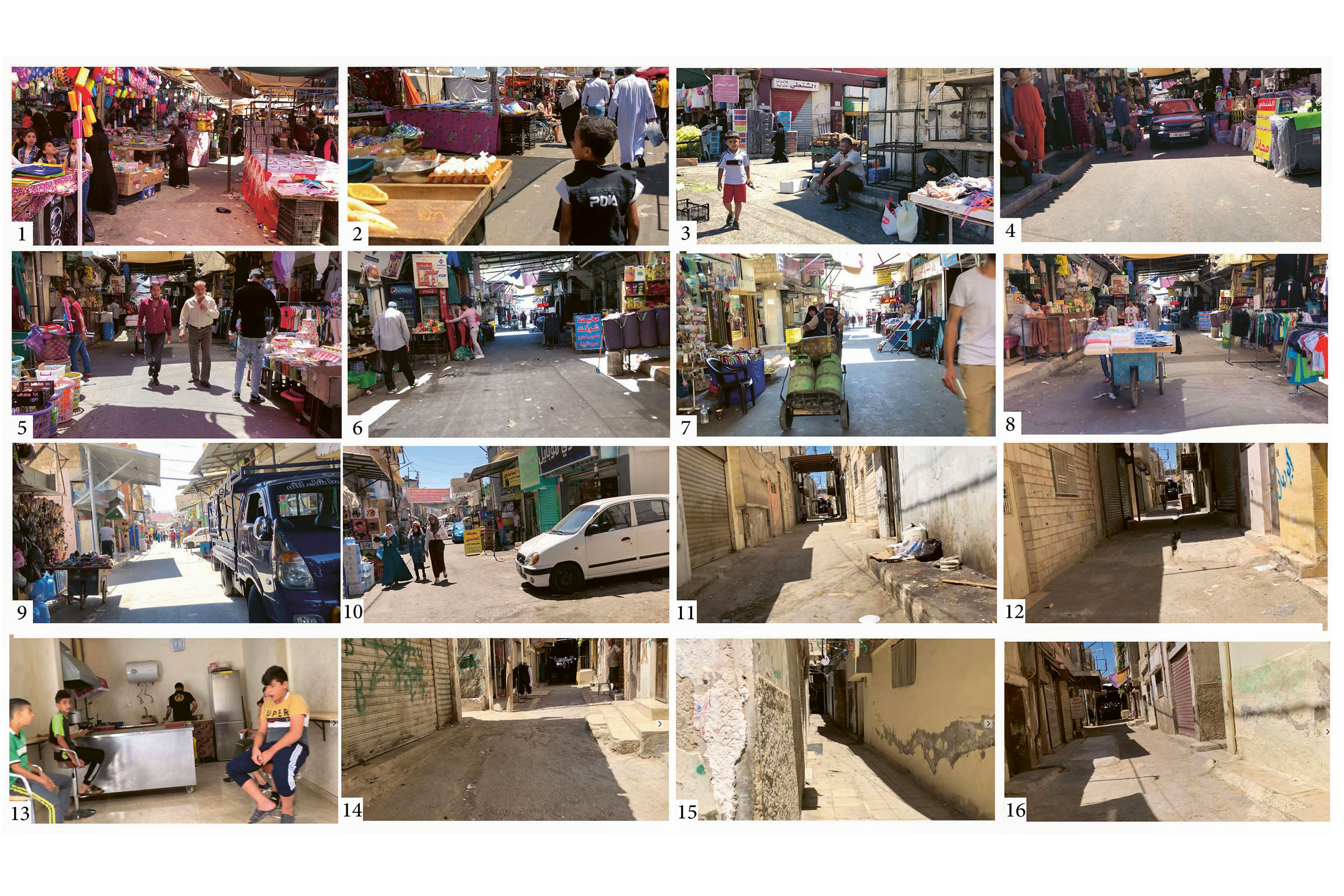
Items ranged from clothing, electronics, furniture, and groceries, with shops clustering by type to create smaller markets: clothes dominated Al Maghfar Street, furniture lined Al Madares Street, and produce spilled from the central vegetable market into the surrounding streets. Walking deeper into the residential neighbourhoods revealed a dramatic decline in noise, activity, colour, and people. The commercial streets were the central stage for these overlapping, maneuvering daily performances. Moving toward the backstage – the parallel streets where most units served as market storage – the environment grew quieter. Further still, the authentic residential neighbourhoods revealed themselves through domestic markers like planters, children playing, elderly sitting outside, and hanging laundry lines, hosting less crowded performances of their own.
Here, it became clear that Al Wehdat was initially a Palestinian refugee camp, where around four generations ironically inhabit four-story residential buildings. To capture this transition from the central stage to the backstage, I used serial vision, taking a series of photographs (fig. 5) from Al Maghfar Street into the interior to capture the sharp drop in activity. Deep in the neighbourhood, away from the chaos that easily obscures the fact, I was reminded that long before the market, Al Wehdat had been a place where people had lived for over six decades since its establishment in 1955. What started as temporary shelters had grown into residential buildings not very different from any other Amman neighbourhood in materials, typology, or building regulations. Because the structures blend so seamlessly into their surroundings, tracing the official camp boundary is challenging, a difficulty further intensified by the fluid movement of people connecting the camp both spatially and functionally with the city.
Officially, the camp territory remains demarcated by Madaba street from the west, Sumaya street to the east, and Al Badiya street to the north, as shown in figure 2. Rather than acting as rigid barriers, these peripheral arteries serve as heavily commodified interfaces with Amman, functioning as vital commercial corridors that extract and channel a relentless influx of consumer capital and outside merchants into southeast Amman. This pervasive commercialization has fundamentally dismantled the camp’s original character as a site of temporary shelter, overwriting it with a market-driven logic that forces a functional, social, and architectural multiplicity onto a space of displacement.
Driven by this economic energy, the market seamlessly transgresses the camp’s official boundaries, further integrating the territory of the camp into the fabric of the city through shared networks and paths of daily activity. This expansion actively blurs a border that has legally demarcated the camp since its 1955 establishment, when its territory was originally constructed on private land leased for 99 years. Ultimately, this material integration directly contradicts the political fiction of the camp’s temporariness, exposing a profound paradox where urban permanence is structurally imposed upon a space legally defined by transience.
Merchants and the Domination over the Camp Space
The emergence of a market-driven economic ecosystem in Al Wehdat has introduced outside merchants as a new class of informal decision-makers who assert spatial hegemony over the camp territory. This commercial expansion has created a profound legal paradox: while local regulations allow inhabitants to convert their shelters into storefronts, they strictly prohibit the sale or rental of these units to third parties. Under UNRWA frameworks, the structures within the camp’s official boundary remain defined as temporary shelters held through a «right-to-use» agreement rather than traditional ownership. To navigate this legal grey area, a robust black market using unofficial papers and shadow lawyers emerged. Interviews with DPA and Merchants Committee officials confirm that the state practiced a policy of «calculated negligence» – knowingly allowing these extra-legal exchanges to persist for decades to foster economic integration while preserving the political fiction of the camp’s temporariness. This official leniency enabled merchants to project power well beyond their storefronts, establishing total control over public space via a stratified tripartite shadow network operating parallel to formal commerce.
The first branch consists of street vendors, or Bastat, who operate under the direct control of «big merchants» and must pay a location-based «protection fee» to secure a spot for their cart or kiosk on sidewalks and roads, facing physical retaliation if they violate these territorial rules. The second branch comprises garbage collectors under mercantile control who distribute the labour of waste management early each morning according to strict territorial boundaries. The third branch involves the illicit trade of drugs and weapons, where some vendors utilize their kiosks as fronts, employing discreet codes and spatial maneuvers to conduct transactions. Although the Bastat are formally illegal, lack work permits, and obstruct urban movement, enforcement is consistently bypassed. Merchants leverage strong connections with the neighbouring Al Ashrafieh Police Station to maintain an early-warning system, allowing vendors to dismantle their setups before state authorities arrive.
This informal expansion causes severe socio-spatial friction within the camp. Residents complain that the Bastat obstruct movement, foster illegal activity, and catalyse harassment, rendering the market an exclusionary and uncomfortable space for women. Independent shop owners also note that the chaos deters shoppers, compromises safety, and introduces unfair competition from vendors who evade rent and regulations, leading to a perceived deterioration of the market. This tension is further exacerbated by a divide between «insider» inhabitants and «outsider» business owners. While outside investors view the camp strictly through the lens of capital and investment rights, camp inhabitants defend the territory as a sovereign site of exclusive historical belonging, transforming the market into a visceral boundary between the camp and the city.
The Fountain Market: Flows of Bodies, Memories, and Water
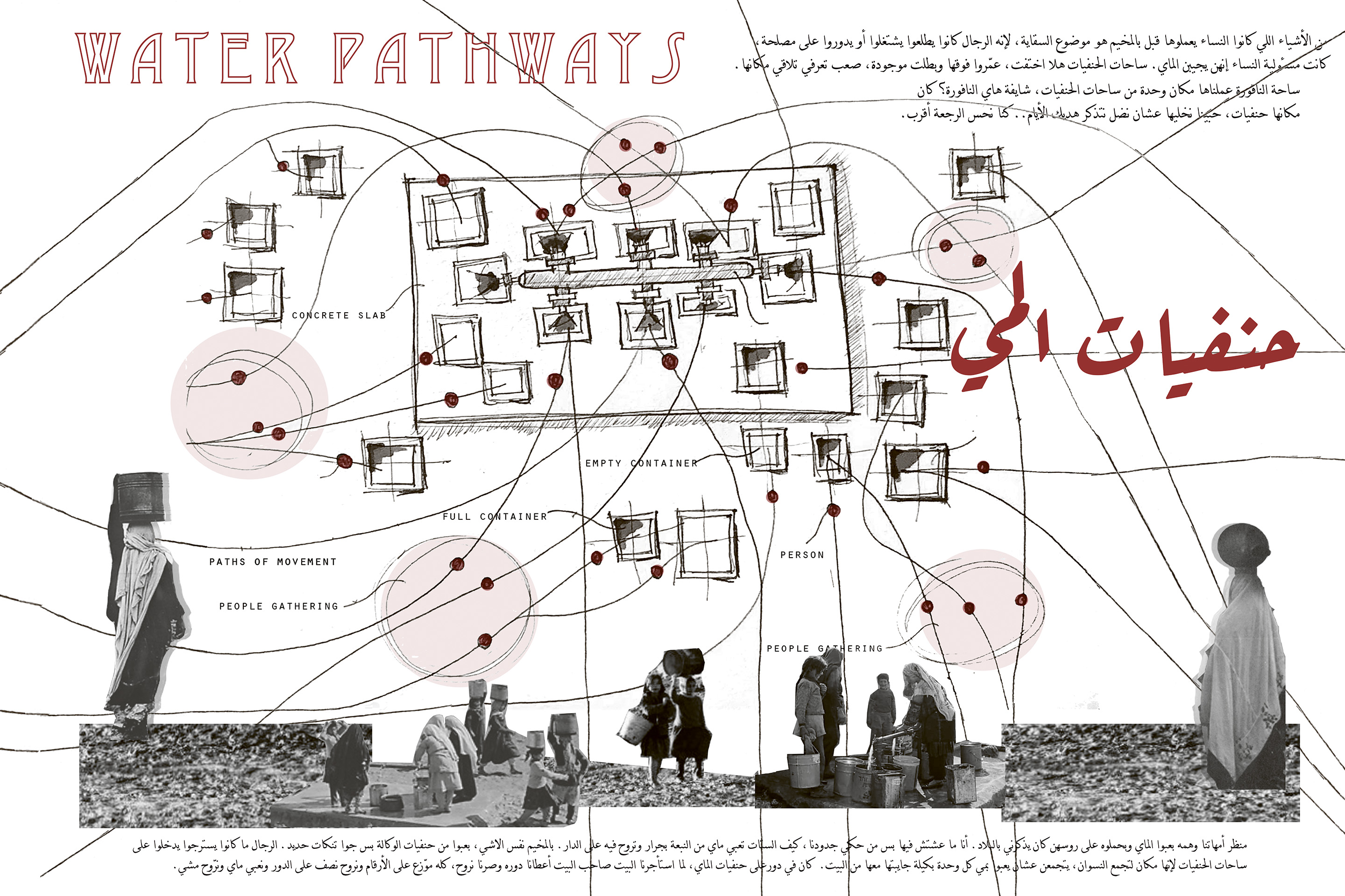
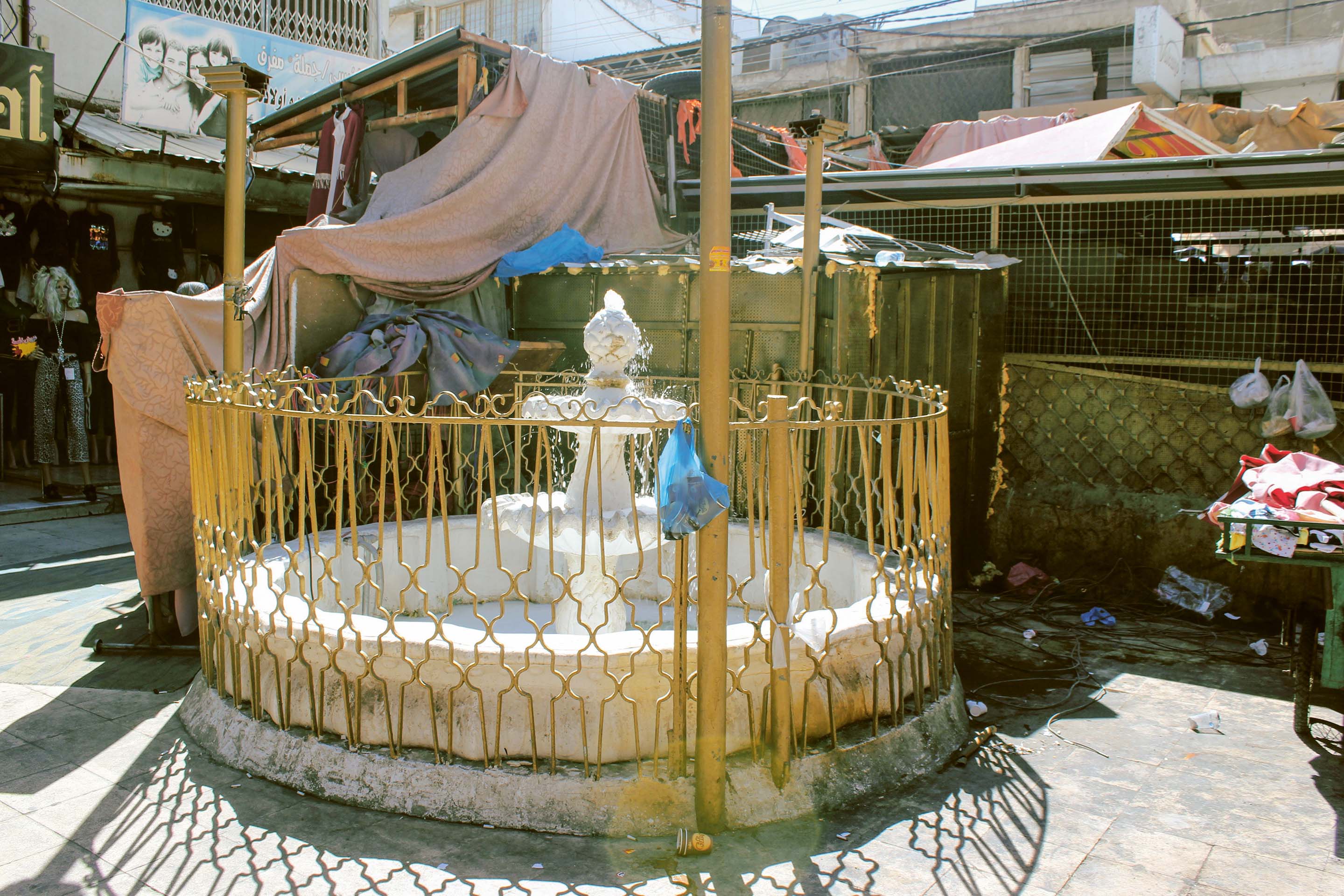
Walking along Al Nadi Street, I accidentally discovered a sign reading Sūq Al Nafoura (The Fountain Market). Inside a small courtyard stood a water fountain built directly on top of what used to be a public UNRWA hydraulic node, as shown in figure 12. According to the camp director, the original shelters lacked plumbing. Inhabitants initially relied on water trucks until UNRWA built public taps across the residential neighbourhoods. These plots, flanked by gender-segregated bathrooms, became sites predominantly occupied by women who lined up to fill buckets and tins using a weekly slot system.
In Ibrahim Nasrallah’s novel Birds of Caution, descriptions of women attempting to secure water strip away any romanticism of the camp’s early days, revealing a harsh and violent everyday reality.
Before public neighbourhood taps were established following petitions, women engaged in brutal «survival fights» around water delivery trucks when they realized the supply was insufficient for everyone. These desperate encounters resulted in physical violence, ripped hair, stained headscarves, and spilled water, though the frequency of these clashes and arguments dropped once local taps were finally built. Nasrallah underscores this brutality through a specific account of his mother, Aisha, who left her baby to seek water from another neighbourhood upon hearing the delivery truck would skip theirs. Driven by fear of running out of water, she pushed into a dense crowd, only to be violently pulled by her hair and thrown into the mud by another woman. When Aisha rose to retaliate, the two women recognized each other, stopped fighting, and embraced – crying both for one another and for themselves.
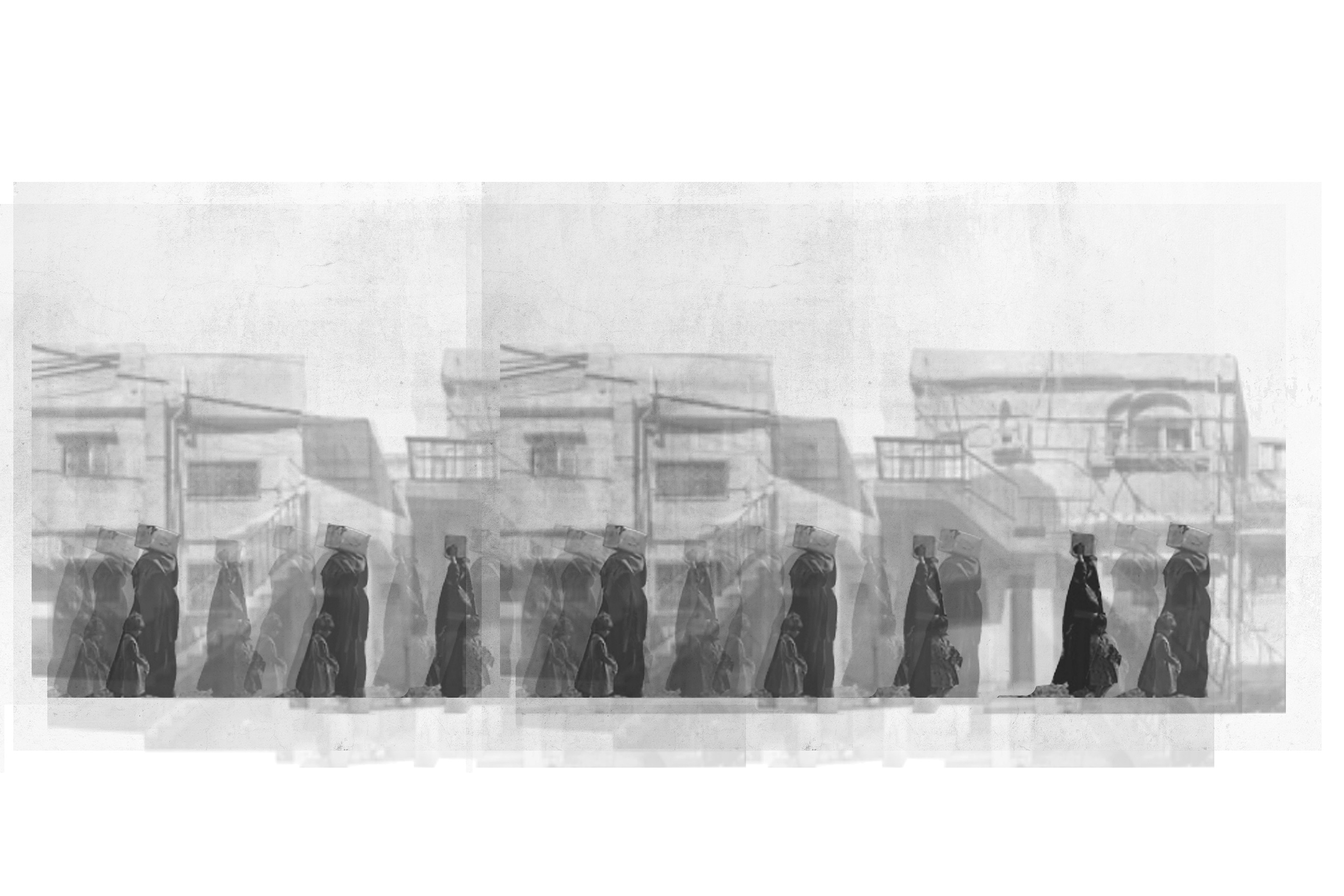
Older women I interviewed vividly recalled carrying heavy water tins over their heads. Because men were out working, fetching water became a gendered daily practice that explicitly occupied the camp’s public spaces. This stands in stark contrast to the present day, where women are far less visible on the streets, having moved behind domestic walls.
To capture this historical labour, I produced the collage (fig. 8) that superimposes past water lines onto recent photographs I took of the camp. This practice aims to excavate women’s spatial memories, highlighting the bodily movement that once produced a distinctly female public domain. For many, this daily queuing for water was reminiscent of Palestine, where women traditionally fetched water from village streams. One elderly resident recalled how his wife carrying a water tin reminded him of his mother carrying a clay jar in his homeland before the 1948 Nakba. A local shop owner shared a similar sentiment, stating that although he was born in the camp, the memory of his mother at the water plots connected him to the stories of Palestine. To preserve this link, local shop owners pooled their own money to build the fountain over the old UNRWA taps, reproducing a piece of their homeland’s memory within the market. This intervention creates a double folding of time and space: the camp’s present folds onto its past, and both fold onto Palestine.
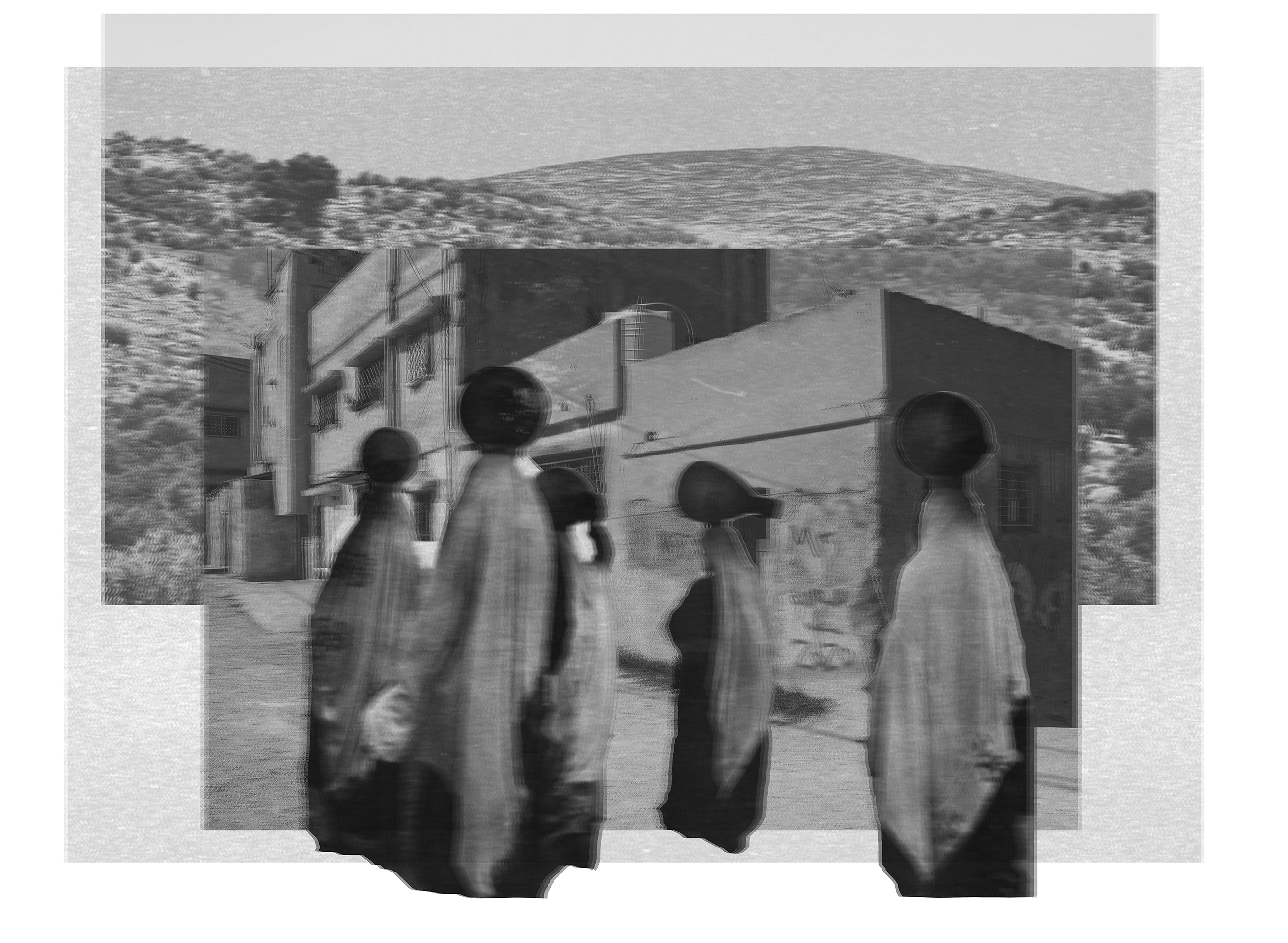
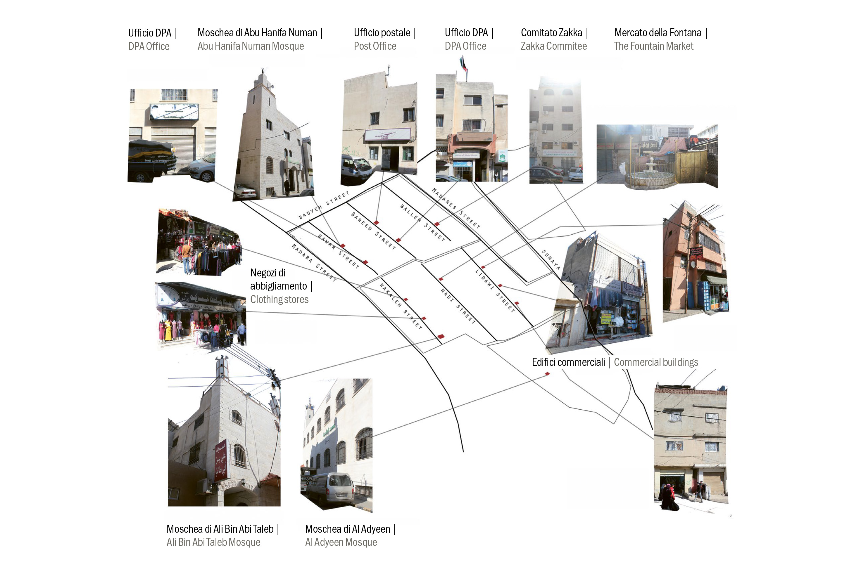
In the collage shown in figure 9, I superimposed an archival photo of women onto a recent image of Al Wehdat, set against a background of Palestinian mountains, bridging the gap of kilometres and years. Deconstructing the camp’s landscape of chaos required archival research, photography, collages, and interviews to see past the market fabric, deeper into the camp’s past, leading all the way to Palestine. Intrigued by the fate of the other UNRWA water plots, I studied a current DPA map to locate them from above. The map revealed evenly distributed small squares between the neighbourhoods where the taps once stood, including the courtyard containing the Fountain Market along Al Nadi Street. The Head of the Engineering Department at the DPA confirmed my findings, noting with amusement that the plots had all been built over, and that even the current DPA building stood on top of a former water plot. Tracking these coordinates on foot, I confirmed that the DPA office sits on a square on Al Bareed Street, adjacent to another square holding the Post Office. Navigating the remaining squares, I mapped the new structures erected over them (fig. 11). These plots have been repurposed for commercial buildings, DPA offices, mosques, the Zakat welfare committee, and the Post Office. The high number of commercial buildings highlights the camp’s total transformation toward market use. Because the DPA issues these building permits, the state has actively directed this spatial transformation. Furthermore, a shop owner noted that some DPA members distributed these plots to well-connected entities, suggesting an overlap between state executors and informal merchant networks.
Through my methodology, I studied the camp as a palimpsest of events, memories, and spatial practices that must be excavated to understand its current integration with Amman. Crucially, the camp cannot be understood outside the history of Palestine; its spaces remain tied to the homeland through the flows of displaced bodies that have arrived since 1948. This preservation of memory extends beyond the water plots; storefront names throughout the market actively commemorate the homeland. Shops bear the names of cities like Al Quds, Nablus, Yaffa, and Bethlehem, alongside smaller displaced villages like Imwas, Beit Nabala, and Al Walajeh. Others use political concepts like
Al Awdeh (The Return) or Al Tahrir (The Liberation), while Sūq Al Dafatyan (The Market of the Two Banks) explicitly references the two banks of the Jordan River.
The Transient Territory and the Doubling of Space
Al Wehdat must be understood as an assemblage of relations where the material permanence of the market directly defies the «temporary» status of the land. This friction creates a «doubling of space,» allowing the camp to exist simultaneously within the material present of Jordan and the symbolic, historical, and future-oriented landscape of the Palestinian homeland. Crucially, this commercialization does not signal the dissolution of refugee space; rather, it highlights how the camp integrates into the wider city through the gradual evolution of its infrastructure and building regulations. Ultimately, the camp operates as an urban palimpsest – a surface where the state, UNRWA, and the refugees themselves continually inscribe new layers of meaning. While the DPA and outside merchants have rewritten the enclave as a regional economic hub, the inhabitants preserve the original text of displacement. By excavating these hidden layers of memory and meaning, this research reframes the camp not as a static, homogeneous non-place, but as a resilient and transient territory. It proves that even as Al Wehdat physically integrates into Amman through concrete and infrastructure, it remains a distinct, enduring archive of the Palestinian struggle for place and return.
Notes
1 Qudah, «Moving Along, Stopping At», 411-433.
2 Abourahme, «Assembling and Spilling-Over», 200-217.
3 Hilal & Petti, Permanent Temporariness, 105-112.
4 Doraï, «Palestinian Refugee Camps»; Doraï, «Refugees and the Urban Fabric»; Ramadan, «Spatializing the Refugee Camp».
5 Augé, Non-Places.
6 Hamdan, El Faouri, Teba, & Yaghi, «Evaluating “Pocket” Public Spaces», 59-84.
7 Achilli, «Al-Wihdat Refugee Camp».
8 Alnsour & Meaton, «Housing Conditions», 65-73; Hamdan, El Faouri, Teba, & Yaghi, «Evaluating “Pocket” Public Spaces», 59-84.
9 UNRWA, «Amman New Camp (Wihdat) Profile»; dpa.gov.jo
10 Oesch, «Refugee Camp as a Space», 110-120.
11 Achilli, «Disengagement from Politics», 234-257; Achilli, «Becoming a Man in Al-Wihdat», 263-280.
12 Achilli & Oesch, «Spaces of Ambiguity», 17-36; Bleibleh, Perez, & Bleibleh, «Palestinian Refugee Women», 2897-2916; El-Zakka & Diab, «Youth Development».
13 Corboz, Land as Palimpsest, 12-34.
14 Nora, «Between Memory and History», 7-24.
15 Nasrallah, Birds of Caution.