AI-powered Conservation Co-pilots for Build Heritage

Testo in italiano al seguente link
Localised decay in built heritage emerges from the complex synergy of climate, materials, and geometry, a process often overlooked by both large-scale climate models and isolated material science. This disconnect obscures our ability to anticipate how climate change will reshape specific degradation patterns. This contribution investigates Artificial Intelligence (AI) as the critical bridge between these scales, proposing Extended Reality (XR) Copilots as intuitive tools to help conservationists forecast and mitigate future risks.
Introduction
The field of heritage conservation mirrors the complexity of the objects it seeks to preserve, requiring practitioners to balance qualitative and quantitative considerations across both global and local scales. This highly interdisciplinary field integrates materials science, microclimate analysis of complex geometries, and architectural concerns related to structural integrity. Moreover, it must consider the monument’s specific history, accounting for historical interventions shaped by evolving restoration philosophies. This intricacy enriches conservation science, but it also makes communication more challenging.
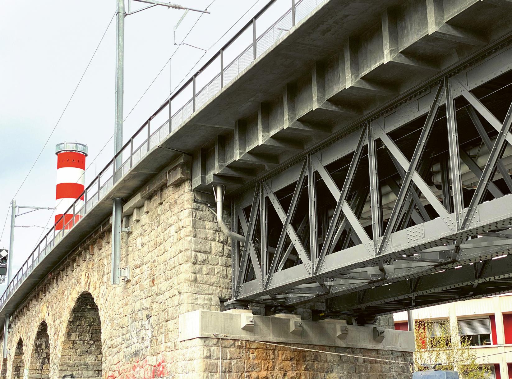
Built heritage exists in continuous exchange with its environment, resulting in uneven patterns of degradation across a monument (fig. 3), all of which involve water in one way or another.1 Hence, daily and seasonal weather cycles strongly influence deterioration processes.2 However, these remain difficult to understand due to highly variable «boundary conditions» that include not only climatic exposure but also material heterogeneity and the cumulative history of conservation interventions.
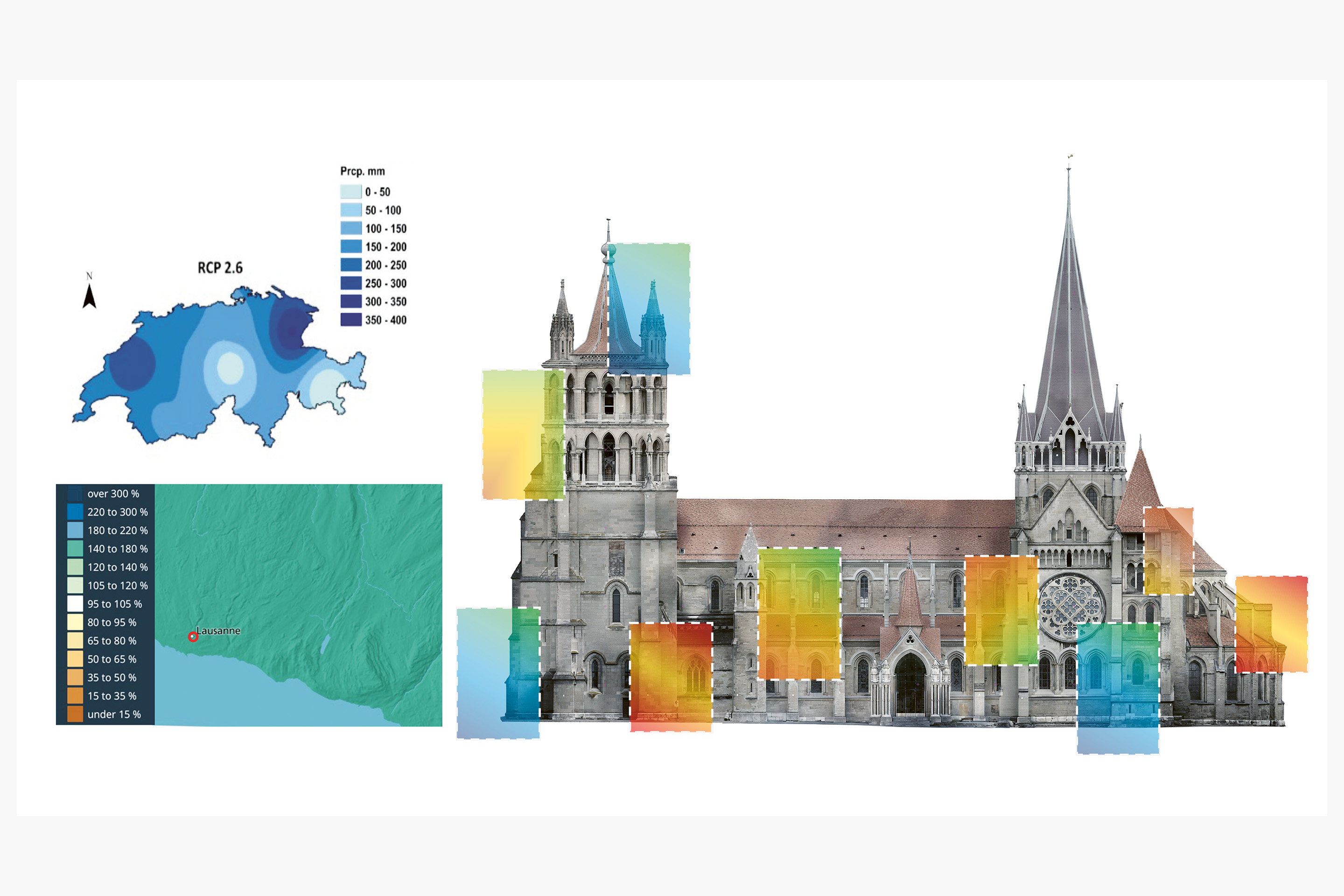
Climate change further complicates this picture by altering weather patterns beyond the experience of field practitioners.3 This has led to a growing number of studies applying climatology to heritage conservation.4 Unfortunately, global climate models are typically resolved at kilometres scale. This means that they fail to capture the local conditions under which degradation acts on monuments, where orientation, geometry, material, and immediate surroundings are decisive. There is therefore a real need to find ways of connecting the length scales of climate models and stone deterioration on monuments, as illustrated in Figure 2: Schematic representation of downscaling global and regional weather data to the monument scale of Lausanne Cathedral, illustrating the relative influence of local geometry and surrounding architectural features .
Recent developments in AI and Spatial Computing offer promising means of addressing these challenges. In particular, AI and Extended Reality (XR) are being explored as means to relate environmental data to the material and spatial specificity of stone-built heritage.5 Conceived as «Conservation Copilots,» these tools support the assessment of decay and the evaluation of interventions, while preserving the central role of expert judgment. This contribution outlines an initial approach to integrating these complementary forms of knowledge to support conservation strategies in view of climate change.
The impact of climate on stone degradation
Atmospheric pollution has long been recognised as a major climatic driver of stone deterioration, particularly through acid pollutants such as sulphur dioxide and nitrogen oxides affecting carbonaceous stones.6 With significant improvements in air quality over recent decades, their impact has declined. To assess long-term climatic trends, surface recession maps have been developed by combining climate projections with average recession rates .7
These studies operate with aggregate material properties and coarse spatial resolution, blending the behaviour of different stone types while overlooking orientation and geometry-dependent effects. Therefore, they are best suited to providing qualitative indications of future trends in support of regional and/or urban scale decision-making.8
Comparable limitations apply to studies of freeze-thaw damage under climate change.9 The physical processes involved are difficult to capture, particularly because they depend strongly on local exposure. Consequently, assessments tend to operate at large spatial scales and rely on simplified indicators, such as the annual number of freeze-thaw cycles, for regional evaluation.10
For monuments such as the Lausanne Cathedral, such studies suggest a reduction in damage related to atmospheric pollution and freeze-thaw cycles. By contrast, processes such as salt crystallisation, clay swelling, and biological growth are expected to become more relevant. These forms of degradation are difficult to predict, making reliable future projections particularly challenging at the scale of the monument.
The complexity and local specificity of monuments are often best understood by field experts. Their knowledge is shaped by years of experience, supported by scientific insight, and refined over time. Yet this tacit knowledge is rarely integrated into academic modelling approaches, which tend to be characterised by attempts of unidirectional knowledge transfer to decision-makers and field practitioners. This disconnect may help explain the limited practical uptake of modelling tools noted in recent reviews. Interestingly, those reviews also emphasise that intuitive and high-quality graphical interfaces represent a promising route to better engage practitioners with the implications of modelling-based research.11
The present contribution explores the use of such interfaces, in combination with an alternative approach to assess the impact of climate change on stone deterioration. Its premise is that the decay is mainly driven by a limited number of harsh events that are recurrent but not frequent, in contrast to rare catastrophic events.12 Examples of these harsh events would include intense wetting followed by rapid drying. Moreover, because wind-driven rain (WDR) plays a central role in these processes, its distribution around monuments is expected to reflect the distribution of degradation patterns. Intuition and experience have trained field practitioners to identify the dependence of decay mechanisms on specific orientations and geometries of a monument. We therefore infer that WDR distributions should be a degradation driver that they could easily come to grips with and use to infer future changes in deterioration distributions.
Therefore, we hypothesise that projections of how weathering exposure may change around monuments in the future would support field practitioners in anticipating how degradation patterns would evolve. It represents a new paradigm of how to get mutual benefit from domain experts in conservation and climatology applied to built heritage. However, for this to be successful, it is important for the model predictions to be accessible in an intuitive way, and contextualised on-site. This is why we are working with XR for our Conservation Copilots, a promising strategy to bring together observational knowledge and scientific modelling to support situated conservation strategies.13
Monitoring and modelling the role of climate
Effective conservation depends on timely access to information and on an understanding of how microclimatic conditions influence material degradation. In recent years, this has motivated approaches that combine monitoring, geometric analysis and planning.14 Water remains a primary driver of degradation in built heritage, originating from rainfall, capillary rise and condensation.15 While vertical rain can often be mitigated through architectural measures, WDR is more difficult to control and is strongly conditioned by local microclimate, geometry and surroundings.16 Its assessment relies on a range of approaches, including direct measurements,17 semi-
empirical methods,18 and computational fluid dynamics modelling (CFD).19
Direct measurements provide essential reference data but are often impractical for complex or inaccessible historical geometrie.20 Conversely, CFD offers detailed, non-invasive assessments but remains computationally demanding and typically limited to selected weather scenarios.21 Semi-empirical models, despite being easier to apply, struggle to capture architectural complexity and often underestimate the effects of sheltering and wind-blocking effects.22 Existing studies aim to improve and combine these models by generating refined Wall Factors using Machine Learning (ML).23 However, fully accounting for the geometric specificity of historic buildings remains challenging, pointing to the need for hybrid approaches that combine monitoring, modelling and spatial descriptions.
Advances in 3D documentation, such as laser scanners, photogrammetry and automated point-cloud analysis24 can facilitate this. Through their geometric parameters, including orientation, height, surface profiles and definition of surrounding elements and exposure, they offer structured insights into discrepancies caused by the generalised wall factors used in semi-empirical methods. More importantly, this provides a rational basis for deriving localised wall factors, enabling more accurate predictions of the distribution of WDR around monuments, without resorting to computationally prohibitive fluid dynamic simulations.
Physics-Informed Machine Learning (PIML) offers a way to do this efficiently, while maintaining physical consistency. However, it requires ample experimental data and gaps therein may be an issue, for example, owing to sporadic sensor malfunctions. Solutions to this can involve using ML-based imputation25 or synthetic data generated through CFD simulations. With this in hand, geometric descriptors, such as surface orientation, normal and volumetric relationships, extracted from 3D models using Python-based frameworks such as COMPAS,26 we have a spatial logic and framework for deriving the distribution of harsh events.
Finally, Long Short-Term Memory (LSTM) models are being explored to capture the sequential features of weather events,27 potentially accounting for the inertia inherent in wetting and drying cycles. This further enables the identification of harsh events and their forecasting under climate-change scenarios.
Visualising changes in deterioration
The above-mentioned approach makes it possible to recast coarse climate descriptors at the scale of kilometres into predictions of the extent and frequency of harsh events on and around monuments, considering their complex geometries. This enables a fundamental shift in perception, reframing weather from a generalised external forcing into a spatially explicit driver of decay for past, present and future exposures.
As previously explained, such predictions of changes in harsh events represent a critical link that enables domain experts to better anticipate changes in deterioration patterns. Indeed, such specialists typically have an experience-based understanding of which exposures lead to certain types of degradation. Thus, by defining how harsh events may change around a monument, they may also anticipate how degradation patterns may change and thereby devise better long-term conservation strategies.
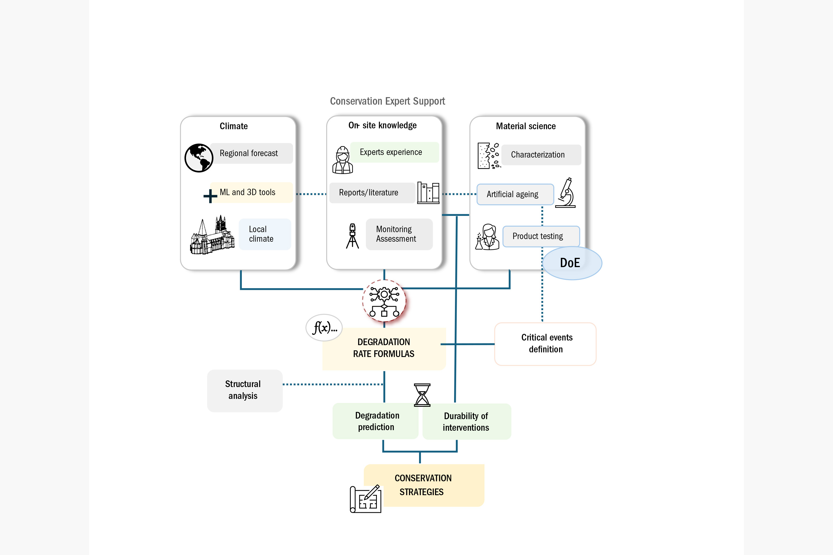
Going from predictions of harsh events to predicting changes in deterioration patterns and rates remains, however, challenging. For this, we need to augment domain
expertise and field observations with principles of conservation material science, lab-based experimental research and structural analyses.28 Promising approaches for this include PIML and statistically based Design of Experiments.29 If successful, as represented in figure 4, this would establish a powerful four-way link between domain expertise, conservation science, structural analysis, and climatology. It would transform digital geometry from a visual aid into a tool that contextualises the predicted impact of environmental stressors. In line with this vision, for example, predictions of harsh events can be used to produce risk maps. As illustrated in figure 1, these maps are spatially resolved at the monument scale, rather than at the regional one.
Conclusions
Applied Climatology for Heritage has emerged as an important field that aims to assess the consequences and risks of climate change for cultural heritage.30 In the case of built heritage, large-scale studies offer general guidance for regional managers, but fine local details remain critical for monument-specific deterioration. The present paper outlined a locally grounded approach centred on water-driven degradation and WDR.
This enables the prediction of shifts in harsh events that represent a unique opportunity to help domain experts recast their understanding of degradation on specific monuments in view of climate change. For this to be successful, it is necessary to develop pipelines of enriching this recast domain expertise through conservation science, laboratory studies and structural analysis. Most importantly, this information must be delivered in a highly accessible and intuitive way. AI- and XR-powered Conservation Copilots are the means we have identified to achieve this.
Notes
- Siegesmund, Siegfried, & Rolf Snethlage. «Stone in Architecture: Properties, Durability». Springer, (2014) https://doi.org/10.1007/978-3-642-45155-3
- Praticò, Ylenia. «Practical Applications of Science for the Conservation of Built Heritage: Strategies Based on the Analysis of Critical Events». Doctoral Thesis ETH Zürich, 2020.
- Orr, Scott Allan, Maureen Young, Dawson Stelfox, Joanne Curran, & Heather Viles. «Wind-Driven Rain and Future Risk to Built Heritage in the United Kingdom: Novel Metrics for Characterising Rain Spells». Science of The Total Environment (2018): 640–641, 1098–111 https://doi.org/10.1016/j.scitotenv.2018.05.354.
- Brimblecombe, Peter, & Jenny Richards. «Applied Climatology for Heritage». Theoretical and Applied Climatology 155, no. 8 (2024): 7325–33 https://doi.org/10.1007/s00704-024-05059-6
- Patankar, Yamini, & al. «Heritage ++, a Spatial Computing Approach to Heritage Conservation». RILEM Technical Letters 9 (2024): 50–60 https://doi.org/10.21809/rilemtechlett. 2024.202
- Camuffo, Dario, Cristina Sabbioni, & Marco Del Monte. «Origin and Growth Mechanisms of the Sulfated Crusts on Urban Limestone». Water, Air, and Soil Pollution 19, no. 4 (1983): 351–59 https://doi.org/10.1007/BF00159596
- Bonazza, Alessandra, Palmira Messina, Cristina Sabbioni, Carlota M. Grossi, & Peter Brimblecombe. «Mapping the Impact of Climate Change on Surface Recession of Carbonate Buildings in Europe». Science of The Total Environment 407, no. 6 (2009): 2039-50 https://doi.org/10.1016/j.scitotenv.2008.10.067.
- Brimblecombe, Peter, & Jenny Richards. «Applied Climatology for Heritage». Theoretical and Applied Climatology 155, no. 8 (2024): 7325–33 https://doi.org/10.1007/s00704-024-05059-6
- Grossi, Carlota M., Peter Brimblecombe, & Ian Harris. «Predicting Long Term Freeze–Thaw Risks on Europe Built Heritage and Archaeological Sites in a Changing Climate». Science of The Total Environment 377, no. 2 (2007): 273–81 https://doi.org/10.1016/j.scitotenv.2007.02.014;
Richards, Jenny, & Peter Brimblecombe. «Multi-Model Ensemble of Frost Risks across East Asia (1850–2100)». Climatic Change 177, no. 4 (2024): 68 https://doi.org/10.1007/s10584-024-03723-4- Grossi, Carlota M., Peter Brimblecombe, & Ian Harris. «Predicting Long Term Freeze–Thaw Risks on Europe Built Heritage and Archaeological Sites in a Changing Climate». Science of The Total Environment 377, no. 2 (2007): 273–81
https://doi.org/10.1016/j.scitotenv.2007.02.014- Richards, Jenny, & Peter Brimblecombe. «The Transfer of Heritage Modelling from Research to Practice». Heritage Science 10, no. 1 (2022): 17 https://doi.org/10.1186/s40494-022-00650-4
- Bonazza, Alessandra, & Alessandro Sardella. «Climate Change and Cultural Heritage: Methods and Approaches for Damage and Risk Assessment Addressed to a Practical Application». Heritage 6, no. 4 (2023): 3578–89 https://doi.org/10.3390/heritage6040190
- Khatri, Ishita, Yamini Patankar, Rafael Bischof, Bernd Bickel, & Robert J. Flatt. «Domain Expert 2.0: AI-Driven Documentation of Domain Expertise in Built Heritage». Proceedings of the 14th International Conference on Structural Analysis
of Historical Constructions, (2025): 847–878 https://link.springer.com/chapter/10.1007/978-3-032-13469-1_69- Jouan, Pierre, & Pierre Hallot. «Digital Twin: Research Framework to Support Preventive Conservation Policies». ISPRS International Journal of Geo-Information 9, no. 4 (2020) https://doi.org/10.3390/ijgi9040228
- Sass, Oliver, & Heather Viles. «Heritage Hydrology: A Conceptual Framework for Understanding Water Fluxes and Storage in Built and Rock-Hewn Heritage». Heritage Science 10, no. 1 (2022): 66 https://doi.org/10.1186/s40494-022-00693-7
- Tang, Wei, Cliff I. Davidson, Susan Finger, & Kirk Vance. «Erosion of Limestone Building Surfaces Caused by Wind-Driven Rain: 1. Field Measurements». Atmospheric Environment 38, no. 33 (2004): 5589–99 https://doi.org/10.1016/j.atmosenv.2004.06.030
- Tang, Wei, Cliff I. Davidson, Susan Finger, & Kirk Vance. «Erosion of Limestone Building Surfaces Caused by Wind-Driven Rain: 1. Field Measurements». Atmospheric Environment 38, no. 33 (2004): 5589–99 https://doi.org/10.1016/j.atmosenv.2004.06.030.;
Praticò, Ylenia. «Practical Applications of Science for the Conservation of Built Heritage: Strategies Based on the Analysis of Critical Events». Doctoral Thesis ETH Zürich, 2020;
Weichbrodt, Anjo, Ylenia Praticò, Fred Girardet, George W. Scherer, & Robert J. Flatt. «Water Transport and the Degradation of Sandstone Monuments: Following the Water Trail at Lausanne Cathedral and Its Swiss Molasse Sandstone». International Journal of Architectural Heritage, 2025, 1–27 https://doi.org/10.1080/15583058.2025.2538115- Straube, John. «Simplified Prediction of Driving Rain on Buildings». Building Science Digest 148 https://buildingscience.com/sites/default/files/migrate/pdf/BSD-148_Simplified_Prediction_Driving_Rain.pdf
- Blocken, Bert, & Jan Carmeliet. «A Review of Wind-Driven Rain Research in Building Science». Journal of Wind Engineering and Industrial Aerodynamics 92, no. 13 (2004): 1079–130 https://doi.org/10.1016/j.jweia.2004.06.003
- Raffler, Susanne, Stefan Bichlmair, & Ralf Kilian. «Mounting of Sensors on Surfaces in Historic Buildings». Energy and Buildings, Special Issue: Historic, historical and existing buildings: designing the retrofit. An overview from energy performances to indoor air quality, vol. 95 (2015): 92–97 https://doi.org/10.1016/j.enbuild.2014.11.054
- Wang, Liping, & Nyuk Hien Wong. «Coupled Simulations for Naturally Ventilated Rooms between Building Simulation (BS) and Computational Fluid Dynamics (CFD) for Better Prediction of Indoor Thermal Environment ». Building and Environment 44, no. 1 (2009): 95–112 https://doi.org/10.1016/j.buildenv.2008.01.015
- Blocken, Bert, & Jan Carmeliet. «A Review of Wind-Driven Rain Research in Building Science». Journal of Wind Engineering and Industrial Aerodynamics 92, no. 13 (2004): 1079–130 https://doi.org/10.1016/j.jweia.2004.06.003
- Gholamalipour, Payam, Ted Stathopoulos, & Hua Ge. «Refined ISO Model for Wind-Driven Rain (WDR) on Buildings: Machine Learning-Based Approach». Building and Environment 285 (2025): 113522 https://doi.org/10.1016/j.buildenv.2025.113522
- Penjor, Tshering, Saeed Banihashemi, Aso Hajirasouli, & Hamed Golzad. «Heritage Building Information Modeling (HBIM) for Heritage Conservation: Framework of Challenges, Gaps, and Existing Limitations of HBIM». Digital Applications in Archaeology and Cultural Heritage 35 (2024): e00366 https://doi.org/10.1016/j.daach.2024.e00366
- Lu, Biao, Yunjie Li, Xianqi Huang, Min Jiang, & Chi Feng. «Predicting Wind-Driven Rain Amount on Building Facade Based on Machine Learning Models». Building and Environment 282 (2025): 113308 https://doi.org/10.1016/j.buildenv.2025.113308.
- Van Mele, Tom, & al. «COMPAS: A Framework for Computational Research in Architecture and Structures». 2017 https://doi.org/10.5281/zenodo.15593771
- Gao, Jiaxin, Yuanqi Cheng, Dongxiao Zhang, & Yuntian Chen. «Physics-Constrained Wind Power Forecasting Aligned with Probability Distributions for Noise-Resilient Deep Learning». Applied Energy 383 (2025): 125295 https://doi.org/10.1016/j.apenergy.2025.125295
- Maia Avelino, Ricardo, Wenqian Yang, Anjo Weichbrodt, John Ochsendorf, & Robert J. Flatt. «Augmented Reality for Structural Inspection of Historic Monuments: The Case of Lausanne Cathedral». International Journal of Architectural Heritage, 7 November 2025, 1–16 https://doi.org/10.1080/15583058.2025.2578318
- Praticò, Ylenia. «Practical Applications of Science for the Conservation of Built Heritage: Strategies Based on the Analysis of Critical Events». Doctoral Thesis ETH Zürich, 2020.
- Brimblecombe, Peter, & Jenny Richards. «Applied Climatology for Heritage». Theoretical and Applied Climatology 155, no. 8 (2024): 7325–33 https://doi.org/10.1007/s00704-024-05059-6